
May 26, 2025 by Ki | Florida’s Hidden History
Some places shape a river. Others shape a region.
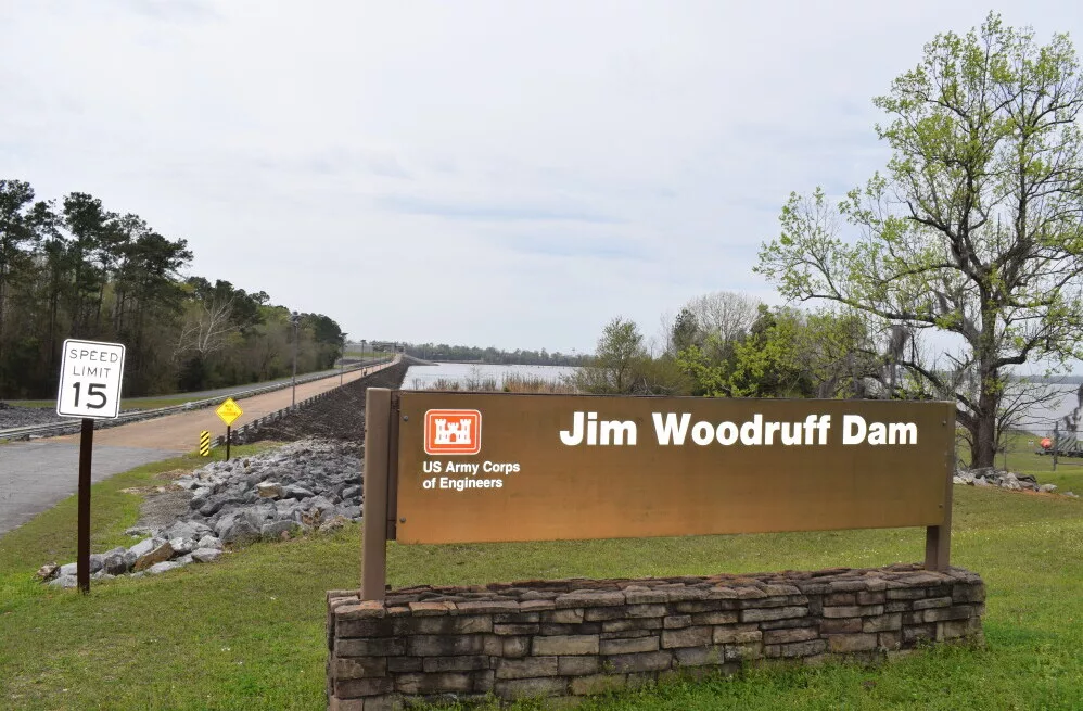
The Jim Woodruff Lock and Dam does both.
Tucked along the state line between Florida and Georgia, this isn’t just a concrete wall holding back water — it’s where the Chattahoochee and Flint Rivers shake hands and merge into the mighty Apalachicola. It’s part muscle, part memory. A place where flood control, navigation, power, and history all flow together.
Dusty and I stopped by on a quiet afternoon, hoping to catch a view from River Landing Park. The overlook gate was locked that day — a classic Murph moment — but the view from below was still powerful. Mist curled off the surface like steam rising from something ancient, and we stood there for a while, letting the hum of the turbines and the churn of the water speak for itself.

📍 Jim Woodruff Lock and Dam: What It Is & Why It Matters
Located just south of the Florida-Georgia line in Chattahoochee, Florida, this lock and dam system is managed by the U.S. Army Corps of Engineers. But it’s much more than a feat of engineering.
It was built to:
Keep the Apalachicola River deep and navigable for barges and boats
Generate clean hydroelectric power for nearby communities
Prevent downstream flooding during heavy rains
Store water for towns and agriculture
Support wildlife habitats around Lake Seminole
And if you pull out a map, you’ll see how big this project really is. Lake Seminole — created by the dam — covers more than 37,000 acres, stretching north into Georgia and curling through the edges of Florida. It’s a haven for fishing, boating, birdwatching, and bass tournaments, and it fuels both adventure and livelihood all around its shores.
But the dam is more than just infrastructure. It’s a symbol of collaboration between two states, two histories, and thousands of lives shaped by the rivers that run through them.
⏳ A River Reimagined: The History Behind the Dam
The story of Jim Woodruff Dam begins long before the first concrete was poured.
In the early 1900s, commercial river traffic was booming… and struggling. Shallow stretches, shifting sandbars, and unpredictable flows made it tough for barges to carry goods like lumber and crops. Local leaders saw a solution in a bold idea: tame the river with a dam that could control depth, flow, and passage.
Construction began in 1947. By 1957, the lock and dam were officially open. The project was named for Jim Woodruff, a Georgia businessman and advocate who championed river development for decades. His name now anchors one of the most important water control systems in the Southeast.
Once complete, the dam stabilized water levels, created a reliable route for river navigation, and gave birth to Lake Seminole — reshaping the landscape and economy of the tri-state area.
💡 Power, Passage & Purpose: How It All Works
The Dam
A concrete spine across the river, built with nine massive spillway gates. These gates open when water needs to be released, lowering flood risk and helping control downstream flows.
The Lock
Think of it as a water elevator for boats. The lock chamber raises or lowers vessels to match water levels on either side of the dam, allowing commercial and recreational traffic to keep moving along the riverway.
The Hydroelectric Plant
On the Florida side, water rushes through turbines that generate up to 36 megawatts of renewable power — enough to light up thousands of homes. If you visit after a good rain, the turbines roar like thunder, and mist hovers over the river like something out of a dream.
📸 Echo’s Corner: Did You Know?
This is the exact spot where the Apalachicola River is born — right where the Chattahoochee and Flint collide.
The dam’s lock is one of the southernmost on the U.S. inland waterway system.
The roar of the spillway has become a local legend. Longtime residents say you can hear it from town after a flood release.
Jim Woodruff, the dam’s namesake, pushed for better river management even after his earliest proposals were ignored.
🌿 Benefits That Flow Beyond the Water
The Jim Woodruff Dam doesn’t just control water — it sustains life and livelihood:
Navigation: Barges move goods between inland ports and the Gulf of Mexico. It’s a working highway of water.
Flood Control: During heavy rains, the spillway gates open to release water and protect farms and towns downstream.
Water Supply: Towns and farms draw water from Lake Seminole for drinking, irrigation, and everyday life.
Recreation: Lake Seminole is beloved by boaters, anglers, birders, and campers. Bass tournaments draw crowds, and families come here to relax on the weekends.
And for many locals, it’s more than a destination — it’s tradition. Generations have fished these waters, picnicked under the pines, and watched the sun dip behind the spillway.

🌱 Challenges and Conservation
Of course, no structure this size comes without trade-offs.
Changing water flow has impacted native fish species, especially those that migrate between saltwater and freshwater.
Water rights remain a touchy subject among Florida, Georgia, and Alabama — especially in drought years.
Lake Seminole’s creation flooded forests and farmland, displacing communities and reshaping the land.
But environmental efforts are ongoing. Wildlife agencies monitor the rivers, adjust flow rates, and plant native vegetation. Volunteers help restore habitat, and researchers study fish populations and turtle nesting grounds.
It’s a constant balancing act — but one that reflects a commitment to shared stewardship of the water.
🧭 If You Go: Travel Tips for Visiting the Dam
Viewpoints: Start at River Landing Park in Chattahoochee, or try to catch the upper overlook park if the gates are open.
Lock Watching: Check the U.S. Army Corps schedule to watch boats pass through the lock — it’s mesmerizing.
Photography: Sunrise and misty mornings make for dramatic photos, especially when the turbines are active.
Outdoor Adventures: Nearby parks like Three Rivers (FL) and Seminole State Park (GA) offer camping, hiking, and trails along the lakeshore.
Fishing: Bass and crappie are popular, but check local rules before casting off.
Weather Watch: Pack for quick storms — especially in summer!
Sometimes you’ll find ranger talks or local festivals along the lakeshore. And small towns like Chattahoochee welcome travelers with friendly shops, old-school diners, and stories passed down like river songs. Also, If you’re nearby, don’t miss River Landing Park in Chattahoochee — it’s one of the best places to see the dam up close.

❓Common Questions
Can you visit the dam?
Yes! Several public parks and viewpoints give you great access, and some areas have interpretive signs explaining the dam’s purpose.
Is it safe to fish nearby?
Absolutely. Just be sure to follow local fishing regulations and carry your license.
Are there tours?
Not regularly, but special group tours may be arranged through the U.S. Army Corps or local organizations. Schools often book educational field trips here.
🌊 Final Thoughts
The Jim Woodruff Lock and Dam is more than concrete and turbines. It’s where rivers shift identities, where the old ways of travel are kept alive, and where cooperation still fuels the future.
If you’re drawn to places where history hums quietly behind the scenery, this one’s for you. Love uncovering Florida’s off-the-beaten-path history? Check out Bellamy Bridge and Olustee Battlefield.
Grab your map. Bring your camera. Come see where the rivers meet.
📸 Want to see my photos from the dam? Click here to explore the gallery.
🧭 Planning your own visit? You can find travel tips and nearby spots linked at the end of this post.
From rivers that meet to towns that vanish — don’t miss the next hidden story.

If you see this after your page is loaded completely, leafletJS files are missing.